

May 11, 2016
Learning from the Past: Traditional Flood Control Systems in Japan's Kofu Basin
Keywords: Disaster Prevention / Reduction Newsletter Resilience Water
JFS Newsletter No.164 (April 2016)
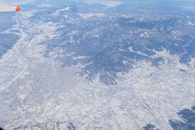
Kofu Basin : Photo by Oita Trip Some rights reserved.
Incidents of heavy rains and floods are increasing around the world as the impacts of climate change are becoming more evident. Japan, too, is experiencing unprecedented heavy and concentrated rains, causing damage from river inundation, floods, and landslides. While it is essential to rapidly decrease the amount of greenhouse gas emissions so as not to further exacerbate global warming, it is also becoming increasingly important to prepare for the effects of global warming that will inevitably occur in the next few decades and beyond.
In Japan, with its limited land and being mostly covered with steep mountainous areas, most rivers are fast-flowing. A Dutch river engineer who was invited to Japan during the Meiji Period (which was 1868 to 1912) reportedly described the Joganji River in Toyama Prefecture as being "not a river, but a waterfall." Located in monsoon Asia, one of the world's heavy rainfall zones, Japan has an annual precipitation of 1,718 millimeters, about twice the world average. The heavy rains are concentrated in the rainy and typhoon seasons. For example, in Tokyo, the precipitation in the wettest month, September, is five times that of December, the driest month.
The Kofu Basin Has Long Suffered from Water-related Disasters
Against this backdrop, flood control has long been crucial in Japan. Flood control measures were also very important projects for samurai leaders during the age of provincial wars (from the end of the 15th century to the end of the 16th century) to empower the capacity of their provinces and stabilize their territories, in addition to the fights on battlefields. From a topographical standpoint, flood control was a great challenge, especially for the leaders of Kai Province (present-day Yamanashi Prefecture), which is located on an alluvial fan and surrounded on all four sides by high mountains.
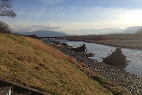
The Kofu Basin is a complex alluvial fan formed by the Midai River, Kamanashi River, and Fuefuki River. Since they run through the alluvial fan and flow freely over its surface naturally, the merging point of the Kamanashi and Midai rivers is extremely vulnerable to damage caused by flooding. The historical record shows that the Kamanashi and the Midai rivers experienced a severe deluge in 1542.
Shingen Takeda, a wartime warrior, is said to have started a flood control project on the Midai and the Kamanashi rivers. According to a local journal, Kaikokushi (1814), compiled in the late Edo Period, Shingen changed the course of the former Midai River to the north, merged it with the Kamanashi River where the flow meets a cliff called Takaiwa, and built an embankment for flood control (known as the Shingen Zutsumi), the only thing confirmed to have been built by Shingen. Other flood control structures are currently being investigated to determine their time of construction and purpose, due to the lack of records available from the age of provincial wars.
This Shingen Zutsumi is said to have been built around 1560. It blocks the river flow toward the center of the Kofu Basin, playing a role in protecting villages downstream. Even after over 400 years, it is still functioning to control flooding. How did people back then manage to redirect a notoriously wild river when there were no technologies or materials such as concrete available to build the high dikes? We visited the still-remaining flood control structures in Yamanashi Prefecture to see what we could learn.
The Flood Control System of the Kofu Basin
The first point for us to learn about the major feature of the flood control system in the Kofu Basin is "formulating countermeasures using the whole basin instead of trying to control flooding with a single flood control structure." Let us introduce a prime example.
First, they launched measures on the Midai River running from the Minami Alps mountainous area toward the Kofu Basin, by changing the river flow at a point where it just enters the basin by building a stone stack called the "Shogi-kashira" (shaped like a piece from the Japanese chess game, shogi). In doing so, the flow of the Midai River could be mitigated compared to direct entry into the basin, which thus reduced the risk of inundation when the river was swollen.
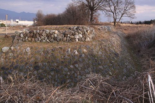
Shogi-kashira : Photo by ChiefHira Some rights reserved.
Then, the course of the Midai River was changed upstream to instead flow into the Kamanashi River. At the confluence point, it hits the Takaiwa cliff, which causes the river to lose momentum.
The confluence then becomes the Kamanashi River. The "Shingen Zutsumi," generically known as a kasumi-tei (see below), was built along the river to prevent inundation water from entering into the central area of the basin.

Figure 1: The Flood Control System of the Kofu Basin
Design Assumes Embankment Will Burst: Resilience Increases
Dikes are usually constructed all the way alongside rivers, but if a dike breaks there is a danger that water may escape at those points. Shingen instead built a discontinuous embankment (or "open levee") system generically called the kasumi -tei ("tei" means levee or embankment).
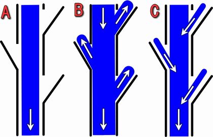
Figure 2. Kasumi-tei (open levee) design:
Normal flow (A), at the time of flooding (B), and after flooding (C)
Source: Fizzle2007 Some rights reserved.
As shown above, the kasumi-tei consists of an unusual series of dikes, with some openings left among them. The arrangements are intentionally discontinuous. When the river is inundated, the overflowing water is directed into the kasumi-tei and retained there. This system dissipates the energy of floodwaters. It also functions to bring the floodwaters, which have lost their energy, back into the main stream. The builders doubled and tripled the number of kasumi-tei on flatlands to make it easier to bring the overflow water back to the Kamanashi River, even when the river is inundated.
It may seem that building dikes without breaks is a strong measure, but once the dikes are breached (as in the case of the Great East Japan Earthquake in 2011) there will be torrential inundation and instant flooding. The kasumi-tei may at first glance seem fragile, but less damage will be caused in a disaster, because they're not meant to completely contain floodwaters. The system uses the power of the entire river on the premise that flooding will happen, and thus it controls the flow. This is a good example of building resilience into design.
Seigyu (Grand Ox) Design Reduces the Momentum of Floodwaters
In addition, structures called Seigyu can reduce the momentum of river water and protect embankments built at places where river flows are strong. This is a local traditional structure designed to control water. The name Seigyu means "grand ox" and is derived from the triangular shape of the base, which is similar to the horn of an ox (in Japanese, gyu).
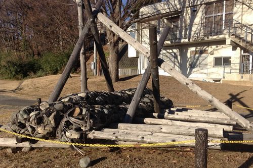
It has a simple shape, with a structure of wood forming a three-sided pyramid. It uses a long bamboo basket ("takejakago") filled with stones for weight. An interesting point is that the structure "grows" in the river. After it is settled in the river, the simple structure captures driftwood, branches, and fallen leaves. Once I tried to pull out a branch sticking out of a Seigyu in the river, but it wouldn't move because the many things sticking out from different angles were firmly entwined and locked in place. This water control structure grows with the power of nature, and is not complete when first installed.
What is wonderful about the Seigyu design is that while it helps control the current during the normal rise of the river, it falls apart during an abnormal swell of water. Usually, a dike is built to maintain itself when put under excessive pressure, but this results in destruction of the surrounding area through scouring (the riverbed and dike base are eroded by strong currents). In contrast, the Seigyu breaks up, which can limit further damage to the surroundings. I was amazed at such a well thought-out design, which is based on the idea of "not fighting against reason."
Even today, there are still many Seigyus here and there along riverbanks, and they are regularly rebuilt.
Manriki Bayashi Woods
Another feature to examine is the Manriki Bayashi woods, located at the apex of the alluvial fan created by the Fuefuki River. This is a flood control system that consists of a mixture of flood control forests (mainly pine trees) and kasumi-tei. When the Fuefuki River overflows during flooding, the big pine trees that grow densely here help keep the area clear from driftwood, earth, and sand. It also helps swollen waters flow back into the river from the openings in the kasumi-tei. The Manriki Bayashi woods were created upstream of populated areas in the Kofu Basin to minimize damage downstream when flooding occurred. Currently, the woods serve as a riverside park that many people love to visit for relaxation. The woods are an example of multi-purpose flood control measures.
Omiyuki Matsuri Festival
In the year 825, massive flooding of the Kamanashi and Midai rivers devastated Kai Province. After that, a shrine was constructed in the Ryuo area and dedicated to a god of flood control. To mark this historic episode, ruler Shingen Takeda started a river management festival, called the Miyuki Matsuri, and promoted it among his people so they would always be aware of the importance of flood control. During the annual festival (every April 15), people march to a shrine beside the Kamanashi River, carrying portable shrines on their shoulders while shouting encouragement and stamping to harden the ground of the "shingen zutsumi" levee. Even today they conduct the ceremony at the shrine each year to pray for flood control.
Conclusion
The flood control measures in the Kofu Basin can be seen as a comprehensive system, consisting of major structures and works constructed (as introduced above), as well as forests grown along the river to prevent massive releases of earth and sand, a festival to raise the awareness of people about the importance of flood control, and tax exemptions for people who maintain the kasumi-tei.
It is amazing that in a time when there were neither airplanes nor helicopters, people constructed such an effective system on a large scale, seeing the basin of three rivers as a whole, and implemented flood control measures with various structures and devices in a multi-layered approach. It is also great that they looked at integrated flood control measures in terms of both the "hardware" (physical infrastructure) and "software" (institutional and social) side (such as the annual festival and tax exemptions).
Above all, I think we can learn a lot from the past. We can cultivate an attitude that avoids the arrogance of assuming that human beings can totally control nature, and we can take multi-layered precautionary measures, including creating structures that grow naturally and are based on the idea that dikes can collapse.
Written by Junko Edahiro
Related
"JFS Newsletter"
- 'Good Companies in Japan' (Article No.4): 'Eightfold Satisfaction' Management for Everyone's Happiness
- "Nai-Mono-Wa-Nai": Ama Town's Concept of Sufficiency and Message to the World
- 'Yumekaze' Wind Turbine Project Connects Metro Consumers and Regional Producers: Seikatsu Club Consumers' Co-operative
- Shaping Japan's Energy toward 2050 Participating in the Round Table for Studying Energy Situations
- 'Good Companies in Japan' (Article No.3): Seeking Ways to Develop Societal Contribution along with Core Businesses
Related
"Popular Articles"
![]()

Some rights reserved. This work is licensed under a Creative Commons Attribution-NonCommercial-ShareAlike 3.0 License.